
Gujarat’s Geography: Land, Climate & Natural Beauty
Gujarat Geography reflects its historical, cultural, and natural diversity. Gujarat is on the western side of India, and it touches many different places around. In the northwest, it shares a border with Pakistan’s Sindh province — places like Tharparkar, Badin and Thatta. On the southwest, there is the Arabian Sea, which gives Gujarat a long and nice coastline. One side it touches Rajasthan, and on the other side is Madhya Pradesh. In the south, it connects with Maharashtra and also the Union Territory called Dadra and Nagar Haveli and Daman and Diu.
A long time ago, north Gujarat was known as Anarta, the Kathiawar region was called Saurashtra, and the south part was called Lata. The Arabian Sea makes up the state’s western coast. The capital, Gandhinagar, is a planned city of Gujarat. This variety in borders and capital layout defines Gujarat Geography clearly. That’s why Gujarat Geography is so widely studied in Indian regional studies.
Gujarat Geography Overview
Every major city reflects some part of Gujarat Geography, from riverside towns to port-based citiesLet’s dive deeper into Gujarat’s Geography and its urban character. Gujarat have so many amazing and different kinds of cities, and each one is special in its own way. Ahmedabad is the biggest one, and it’s super famous for its old city vibes, culture, and it’s growing really fast with industries and all.
Surat is always busy – known for diamonds and clothes stuff – and also, it’s one of the cleanest cities in the country. Then comes Vadodara (some people call it Baroda), which has those royal palaces and also good colleges and schools. Rajkot is also important, kinda historical, and lot of factories are there too. Bhavnagar is near the sea, and people say it’s good for trading things. Jamnagar has huge oil refineries and also some really pretty temples. And yeah, Gandhinagar is the capital – it’s so calm, full of trees and planned nicely. Honestly, all these cities together make Gujarat so interesting – from business to culture, from past to modern-day life.


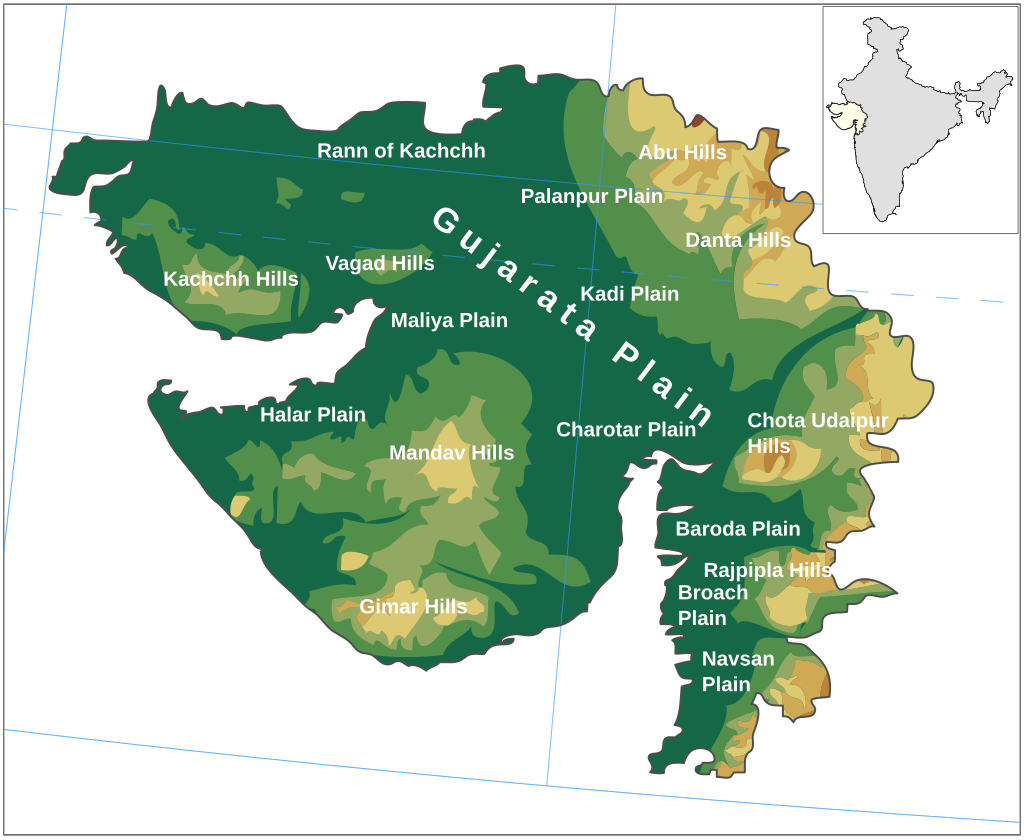
Natural Features in Gujarat Geography
Gujarat has all kinds of natural places, which make it really special. This richness in terrain strengthens Gujarat’s Geography.
On the west side, there is the Rann of Kutch, it is a big white salt desert. It looks super amazing, especially when there’s moonlight – it feels like some movie scene or something. In the south, you got the Gir Forest, and thats like the only place left where Asiatic lions still live freely in wild – pretty awesome, no? Then there’s the long coastline touching the Arabian Sea, with nice chill beaches in Diu and Mandvi where people mostly go to relax and enjoy.
On the east and south part, there are small hills like Satpura and Saputara, full of trees, fresh air, and sometimes waterfalls too during rainy time. Then, big rivers like Narmada, Tapi, and Sabarmati flows through Gujarat – they are super important for farming and daily water needs. Oh and ya, there’s also Nal Sarovar, which is like a big wetland where so many birds come, especially in winters – great for people who love birds and nature. So ya, Gujarat kind of have everything – desert, forest, sea, rivers, hills – all mixed in one state! All these landscapes combine to form the natural identity of Gujarat Geography. Gujarat Geography offers a mix of cultural richness and physical diversity found in few other state.

Rann of Kutch
Rann of Kutch is honestly one of those places that just feels totally different. It’s this massive white desert, and the wildest thing is – it’s actually all salt. Not sand, salt! When you go there in the day, it’s super bright, like you almost need sunglasses even if it’s not sunny. But at night, specially on full moon, it glows – like silver everywhere. It’s hard to explain, but it’s really something you gotta see. Every year they do this thing called Rann Utsav – kind of like a festival – with music, dancing, yummy food, and those colourful tents that just look awesome in the desert. But it’s not just fun, you also see local Kutchi people, their clothes and all the handmade things they make. Feels super real and different from city life. It’s also near Pakistan border so the vibe is kinda unique too. I went once and trust me, if you’re going Gujarat, don’t skip this place. It’s big, calm, and stays in your mind for long. Rann of Kutch is one of the most iconic parts of Gujarat Geography.
GIRR FOREST NATIONAL PARK
Hidden deep in Gujarat, is the only place in the whole world where Asiatic lions still live freely in the wild. But honestly, Gir isn’t just about lions. There’s also leopards, hyenas, few types of deer, and lots of birds flying around. The forest mostly dry with scattered trees and big grass patches, but once monsoon hits, the whole place turn green and fresh. Most people go for jeep safaris to explore the park, which is probabaly the best way to actually see the animals in action. If you don’t have much time, Devaliya Safari Park is there too – a shorter ride but you’ll still see lot of animals. The best time to come is from October to June, ’cause the park is closed in the rainy season. The coolest thing? Long back, there were just 12 lions here, and now there’s over 600 – that’s a big win for nature. This conservation success is a proud part of Gujarat Geography.


COASTALLINE
The vast coast is one of the most striking parts of Gujarat’s Geography. Gujarat has one of the longest coastlines in India, longer than 1,600 kilometres along the Arabian Sea. This coastal belt is full of beautiful beaches like Mandvi, Diu, Tithal, Dwarka and Somnath, all known for a peaceful vibe, clean sand, and temples nearby. The coastline also has big ports like Kandla, Mundra and Porbandar, which play an important role in trade and shipping. Along the shore, you can still find old lighthouses and small fishing villages that show the local way of living. In the Gulf of Kutch, there is India’s first Marine National Park, where people can see coral reefs, dolphins, mangroves and more sea life. Some areas also have salt pans and wetlands where many birds like flamingo comes. Gujarat’s coast is not just beautiful but also full of marine life, culture and history, making it a very special part of the state. No doubt, Gujarat Geography benefits immensely from this coastal stretch.
Gujarat`s Geography: Flora and Fauna
Flora and fauna reflect the ecological variety of Gujarat Geography. Surveys say nearly ten percent of Gujarat’s land is covered in trees. In spots like the Gir and Dang forests, you’ll see a bunch of teak, neem, bamboo, and babul trees. But head to drier places like Kutch and Saurashtra, and it’s mostly thorny bushes and cactus – these plants don’t need much water to survive. Near the sea, especially ’round the Gulf of Kutch, you’ll find mangrove trees growin’ right up to the shoreline.
Now, Gujarat? It’s really famous for its animals, too. The animal everyone knows is the Asiatic Lion – and get this, it only lives in the Gir Forest, absolutely nowhere else on the planet! Besides those majestic lions, you’ll find leopards, jackals, hyenas, quick-footed blackbucks, and even the Indian wild ass, just roaming freely in the Little Rann of Kutch.


Sardar Sarovar Dam
Wildlife habitats add depth to Gujarat’s Geography as a natural showcase. The Sardar Sarovar Dam is a big dam built on the Narmada River, near Kevadiya town in Gujarat’s district. It was made mainly to give water and electricity to states like Gujarat, Madhya Pradesh, Maharashtra and also Rajasthan.
The Sardar Sarovar Dam is the biggest among the 25 dams planned along the Narmada River. It’s actually the second-largest concrete dam in the world. It is useful for the district in many ways. This dam is part of the Narmada Valley Project which was started in 1978 where this damn is base for providing irrigation and hydroelectric power across the Narmada. The project is expected to provide water to about 2 million hectares of land, especially helping the dry regions of Kutch and Saurashtra. This will help the city to give a beautiful view of the dam along the Narmada valley and also become a tourist place to attract tourists. The dam and nearby ecosystems also enhance Gujarat Geography as a blend of human development and nature. The project reflects the scale and ambition behind Gujarat Geography’s development. Overall, Gujarat Geography stands out for blending nature, cities, rivers, and coastlines in perfect balance.
For technical details and current water levels, visit the click here

To understand how geography shaped early settlements and trade, check out our article on the History of Gujarat